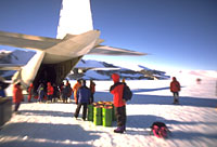
 Alain
Hubert and Dixie Dansercoer will leave aboard a Hercules C130
for Blue One, the second tourist station in Antarctica. They
will take a Twin Otter the day after their arrival, or the day
after that, some 400 km to the east to reach the site of the
former King Baudouin base at 24°18'38" latitude south and
70°25'53" longitude east. That is where they will start
their unassisted crossing of Antarctica.
Alain
Hubert and Dixie Dansercoer will leave aboard a Hercules C130
for Blue One, the second tourist station in Antarctica. They
will take a Twin Otter the day after their arrival, or the day
after that, some 400 km to the east to reach the site of the
former King Baudouin base at 24°18'38" latitude south and
70°25'53" longitude east. That is where they will start
their unassisted crossing of Antarctica. 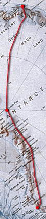
One of the peculiar things about Antarctica is that the average
height of the continent is over 2000 metres, with the South
Pole located at an altitude of some 3000 metres. So whatever
place you approach the 6th continent from, if you intend to
cross it, you have to clear a way to the polar plateau. Aided
by the many pieces of advice heaped on him by Belgian scientists
who have been in this part of Antarctica several times, Alain
and Dixie chose to tackle Gunnestadbreen,
a glacier in the Sør Rondane chain of mountains. This
initial difficulty is located approximately 200 km from the
point of departure.
From the top of the Sør Rondane mountains to the South
Pole, the terrain is flat over a distance of approximately
1500 km. As only a few men (scientists and adventurers combined)
have ever been to this region of Antarctica, no-one could
predict the type of terrain - littered with crevasses or bristling
with sastrugi - that the two Belgians will encounter during
this part of their expedition.
From the South Pole to the American station at McMurdo (located
on the edge of the Ross sea), there are two options for crossing
the trans-Antarctic mountains which stretch from west to east.
They can either go via the Beardmore glacier (the way Robert
F. Scott went during his dramatic conquest of the South Pole,
a way which has become the traditional route for polar adventurers),
or they can take the Axel Heiberg
glacier, which was the route chosen by Roald Amundsen during
the same season (1911-12). Hubert has opted for the Axel Heiberg
glacier for the following reasons:
- Because he is very much a mountaineer, and prefers a steeper,
but shorter route.
- Because this particular spot on the
ice shelf, according to the katabatic wind model
developed by Hubert Gallée (see above), he will probably
be able to take better advantage of the katabatic winds
- and for longer in any case (since the foot of Beardmore
is closer to McMurdo than the Axel Heiberg). The distance
then remaining to be covered from the foot of the Axel Heiberg
glacier to the end of the expedition is certainly greater
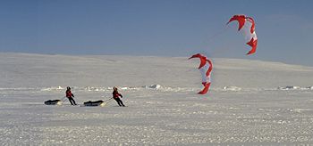
(900 km instead of 700), but Hubert is counting on the twin
forces of the parafoil and the katabatic winds to help them
progress more quickly.
One final difficulty awaits the expedition before it reaches
McMurdo: a small hill of ice located 60 km from the American
base. This distance may appear negligeable compared to the
3800 km that the expedition is planning to cover, but everyone
knows that in the context of the Antarctic, the slightest
detail and the smallest difficulty has to be taken with extreme
seriousness. After all, the English explorer, Robert Falcon
Scott and his two companions (Bill Watson and Birdie Bowers),
died of exhaustion and hunger when they were just twenty kilometres
or so from the last of their stockpiles of stores.
|