|
|
|
|
Introduction of Arctic polar Regions Some people think that the Arctic encompasses all the regions lying between the North Pole and latitude 66°33', called the "Arctic Polar Circle", which in principle delineates the territories where, in summer, the sun never sets.
But such an approach is somewhat inaccurate. In fact the southern frontier of this geographical whole would appear to be more appropriately traced by the timberline, which, far from regular, fluctuates between 55° latitude North (in Labrador) and 71° latitude North (in Scandinavia). The central part of this universe is permanently covered by ice. This is the polar pack. Around this, there is drift ice, then seas which, strewn with floating pieces, icebergs and numerous islands, finally open on to enormous emergent, non-floating expanses, whether insular (Greenland) or continental (Canada, Alaska, Siberia and Scandinavia). There one comes across the domain of the tundra, the last stage before the timberline and the subarctic lands of the taiga. The polar packs
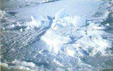
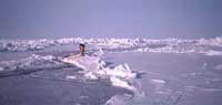
With an average thickness of three to five metres, the polar pack floats on an ocean that is at times reaches a depth of nearly 5,000 fathoms. It is as a result conveyed by the powerful transpolar drift current that flows along Northern Russia. Coming from the Bering Strait, this current carries the ice flow towards the north coast of Greenland, where it splits in two, one continuing along the east coast of this natural obstacle, the other heading off West to go and feed the circular Beaufort current that eddies at the heart of the Arctic Ocean. The polar pack presents a surface of pressure ridges emanating from the meeting of separate ice-fields whose ends overlap to reach maximum heights of about ten metres. This type of event is however fairly infrequent because, on the one hand, of the meteorological calm that reigns at these latitudes and, on the other, of the thickness of the ice layer, which drastically limits the possibility of movement.
Then the Arctic summer arrives. In this period that is characterised by the temperature stabilising between - 5°C and + 5°C and by the appearance of a thick layer of cloud covering the Arctic basin, the ice melts and breaks up even more. In a succession of movements that last until the autumn, the ice-fields are at times reduced to slabs of just a few square metres. The Floes
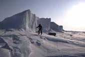
The Icebergs Unlike IIMs, which are flat and not too thick (3.6m at the very most), icebergs can reach a height of 100 metres. This difference is explained by their different genesis. Whereas the first originate from the polar pack, the second come from the lands that surround it, most frequently Greenland and Ellesmere Island. By way of example, Greenland's most prolific glacier, the Jakobshavn, generates 25,000 tons of ice per day. Unlike IIMs, which are flat and not too thick (3.6m at the very most), icebergs can reach a height of 100 metres. This difference is explained by their different genesis. Whereas the first originate from the polar pack, the second come from the lands that surround it, most frequently Greenland and Ellesmere Island. By way of example, Greenland's most prolific glacier, the Jakobshavn, generates 25,000 tons of ice per day. Only a part of an iceberg's total mass of remains above the surface. Between a ninth and a tenth, as the case may be. This variation depends on the characteristics of the glacier, with the more recent ones enclosing a distinctly greater quantity of air than the older ones, which, as a result, prove to be significantly heavier. The Tundra The circumference of the Arctic is made up of an immense plain, of which the north and south edges respectively correspond to the shore of the Arctic Ocean and to the tree line that is called the "timberline". This is the area of the tundra that covers the northern part of all the continents of the boreal hemisphere. Its overall surface area is estimated at 13 million square kilometres, or 1.1% of all emergent land. A huge, white plain swept by violent squalls of freezing wind in winter, the tundra would be a complete desert if a layer of earth and impermeable, permanently frozen rock, the pergelisol (or permafrost), were not to allow the countryside to come back to life again during the summer by forcing the water to remain on the surface. During this warmer period, some regions give birth to a landscape comprising streams, rivers, ponds, lakes and peat bogs before being covered with flowers, plants and dwarf trees. Other, more arid, territories have to be content with sparse vegetation. . The Timberline, entry to subarctic Taiga The timberline snakes between 55° and 71° latitude North. Although its name suggests otherwise, it is less of a line than a transition area of which the width varies from a handful of kilometres to more than 160km from one region to another.
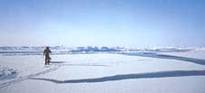
Transition? Yes. For this belt of stunted trees that stretches across prairies strewn with thickets and shrubs marks the frontier between the tundra and the other zone, the taiga, that takes us away from the Arctic territories themselves into the subarctic zone. The Ice Drift The ice raft is not immobile. Under the effect of the wind, and 50 times slower, it drifts from 25' to 45' in relation to the direction of the air. So it is now known that the ice raft floats on water and that it is conveyed by the powerful transpolar drift current that comes from the Bering Strait, flows along Northern Russia and heads for the north coast of Greenland. For its part, the Beaufort current is active between the Canadian archipelago, Northern Alaska and the North Pole. As it circulates within a closed circuit, it traps the ice that has not drifted towards the West of Greenland. This is why the most ancient ice of the glacial Arctic Ocean is to be found at the centre of this current.
|

 In winter, the ground seems to consist of a single block because the ice-fields are unified and monopolise the landscape for as far as the eye can see. Even if there are faults that occasion brutal encounters with salt water at -1.8°C with the air in the region of -40°C, this phenomenon seems both anecdotal and momentary: perhaps a long curtain of steam might possibly appear for something less than an hour, the time to allow the surface water to solidify once again.