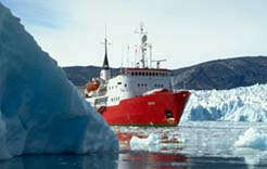
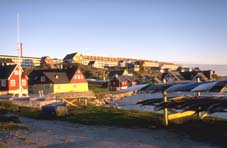
Unknown in the West for a long time, Greenland became a part of European history in the 18th century when it was colonised by Denmark. Emprisoned as such for two centuries, Greenland was given a new constitution in 1953, when it was granted two MPs in the Danish parliament in Copenhagen, whose task it was to defend the interests of the Kakkallissut people. In 1979, Greenland was granted home rule, with Denmark contenting itself for the main with responsibility for its former colony's defence and foreign policy.
Unknown land
For all that, Greenland remains one of the least well known countries in the world. In fact, it is only very recently that the discovery was made that underneath the icecap, Greenland is made up of three islands. According to geoseismic and gravimetric surveys carried out on the icesheet - the 'inlandsis', a Scandinavian word meaning "ice in the midst of the land" - shows the presence of two large cracks dividing the country from one side to the other, between the 69th and 71st parallels. So until a short time ago, it was still unknown whether the "green land" should be considered as the largest island in the world, as the juncture of two islands separated by a gigantic fjord or as an archipelago.
It is true that eight to nine-tenths of the rocky base are covered by a thick layer of ice, through which only the rocky coastline emerges with a few isolated peaks dotted about, known as "nunataks".
Under the water level
Paradox: the icecap reaches a height of 3,270 m, yet geoseismic readings taken at that altitude indicate a thickness of 3,410 m. This apparent anomaly indicates that the thick layer of ice has for thousands of years exerted sufficient weight to push the underlying ground gradually into the Earth's magma. Which is why, as is the case in Antarctica, Greenland's rocky base is now located under the water level. We now know that the base of the icesheet rests on a tectonic plate that is located at a more or less constant depth of 200 to 500 m beneath the water level of the Arctic Ocean and rises gradually towards the coastline...
Basin
Seen in profile, therefore, Greenland presents the image of an immense basin, with the rim enclosing an enormous stretch of ice. Apart from the nunataks, all of the visible mountains are located at the edge of the island. Does this mean the icesheet is totally symmetrical? No. Because the eastern massif is considerably higher than its counterparts to the west and the north. Whatever the latitude, a cross-section illustrates that it is here that the icecap reaches its maximum altitude and thickness.
This asymmetry is explained by the higher precipitation in this part of the country, which does not prevent Greenland's most prolific glacier from plunging into the sea on the west coast. Jakobshavn glacier, as it is known, provides a daily diet of 25,000 tons of icebergs for Baffin Bay, or approximately 1/15,000th of total glacier production, which represents the astronomic figure of 370 million tons. 

Ice and tundra
Although a quarter of its land area is situated below the Arctic Circle, Greenland has no room for taiga. Four-fifths of the land is covered permanently by ice. On the remaining 20%, the tundra produces a miracle for two months every year with green meadows and carpets of multi-coloured flowers. Curiously, the flora is more varied and abundant on the coast open to the icy north-eastern current. Also strange is the fact that flowering plants occur in the extreme north, as well as the south of the country. But on the whole, the environment is particularly inhospitable. Yet a number of animals thrive there, from the polar bear to the musk ox and many others, such as reindeer, seals, walruses, Arctic foxes, lemmings, white wolves and Arctic hares, as well as the only birds that over-winter in Greenland: the great white owl, the gyrfalcon and ptarmigans. Cattle and sheep are also farmed in the south, which has more rainfall and an unpredictable climate. Not forgetting many insects and four species of butterfly in the most southerly part of the country.