|
|
|
|
Antarctic Ice / Introduction Geographically, the Antarctic is divided in two following an imaginary line traced along the 4,000 kilometres of the Trans-Antarctic mountain chain: ·
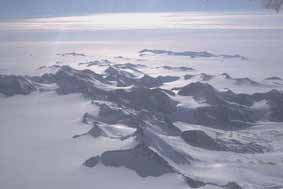
With an average thickness of 2.3 kilometres, the Antarctic ice culminates at 4,776 metres at the point 69° 54' south and 135° 12' east, in Eastern Antarctica (1). These thicknesses decrease towards the coasts: at 200 kilometres from the littoral, the thickness of the ice is no more than 1,500 metres.
(1) " How have these considerable ice thicknesses been measured?", writes Souchez. "The most used technique is the one of radio echo-sounding from an aeroplane. The ice is relatively transparent to radio waves (between 30 and 300 Megahertz), which means that a part of the energy transmitted to the surface of the ice traverses it and is reflected by the ice/bedrock interface. By overflying the ice areas with radar-equipped aeroplanes, one obtains a continuous profile of the glacial surface and the bedrock along the line of flight, even if the thickness of the ice exceeds several thousand metres Thanks to radio echo soundings carried out from aeroplanes, we have obtained, though a grid of lines of flight, a cartography of the sub-ice bedrock in Antarctica and Greenland. By comparing the thicknesses obtained by seismic (or gravimetric) studies and by interpreting the results of the measurements obtained by two independent flights, one can attribute an accuracy of about 1% to the radar measurements. Aerial navigation errors and uncertainty as to the exact altitude positions of the aeroplane have cast doubt on the accuracy of these maps of the sub-ice bedrock, but the use of inertia navigation systems today produces very reliable documents." Roland Souchez, Polar Ice, Brussels University publications, collection "Understanding Progress", 1988, pp 20 & 21
|