|
|
|
An ocean unlike the others Since the development of oceanography dating from the period between the wars, there can no longer be any doubt: the Southern Ocean, formally called the Antarctic Ice Ocean, is the heart of the world ocean. It operates as a powerful engine distributing the quantities of water into the other oceans of the world - Pacific, Atlantic and Indian - upon which the great oceanic movements entirely depend. It is the only ocean in the world that circulates unobstructed around a continent (the only The Southern Ocean also contains the most powerful current in the world; the Antarctic circumpolar current. Oceanographers have calculated (1) that no less than 150 million cubic metres per second (in fact the figures vary from between 130 and 190 million cubic metres) flow between the Antarctic and Africa. That is four times the volume of the Gulf Stream, 400 times the volume of the River Mississippi, and 1,000 times the volume of the River Amazon. Driven by the prevailing winds (the famous Roaring Forties and Furious Fifties) and the Coriolis effect, it flows from west to east over a distance of approximately 24,000 km and is between 200 and 1,000 km wide; in the area around the Antarctic coasts, the gyratory direction of the southern current is reversed and the Antarctic coastal waters flow from east to west. These two areas of hydrological circulation are separated by an imaginary line called "the line of Antarctic divergence"; another separation, the "line of Antarctic convergence" or the "polar front", determined collectively by the wind system, the atmospheric pressure, the submarine circulation of the water mass and the topography of the ocean bed, theoretically separates the actual Antarctic Ocean to the south from the milder sub-Antarctic waters to the north. Another imaginary frontier helps to define the limits of this huge Southern Ocean with greater precision: the subtropical convergence, which undulates around 40° latitude South.
It is from these regions that the water temperature falls sharply: in just a few dozen kilometres, the thermometer in the seawater drops from 17° to 12°C. Further general characteristics of this front are the presence of numerous clouds and an unusually large concentration of sea birds. Although there is some disagreement about these frontiers, and about their names, it can be said that the Southern Ocean begins at this hydrological frontier. At the Polar Front, temperatures drop from 12° to 7°C. This distribution of the water mass is not uniform; in one or two regions of the Southern Ocean, factors such as the rising of the ocean floor or its confused topography - or even the landform of the coasts -act like a vice on the water on the one hand, and on the other hand, like sources of turbulence that can create oceanic eddies like those of the Weddell and Ross Seas, for example, two deep indentations that cut into the Antarctic land.
(1) The calculations were made for the first time by Harald Sverdrup, the erstwhile Director of the Scripps Institution of Oceanography in La Jolla (California) and published in 1942. This eminent oceanographer based his work on the observations made between the wars by the offshore campaigns of the British vessel, Discovery.
|

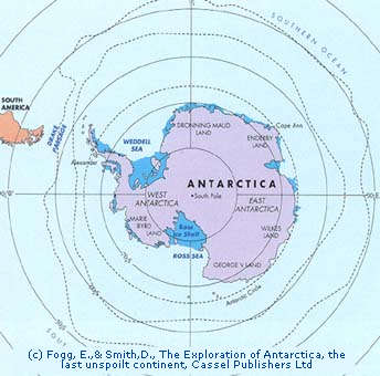 significant slowing-down point being the southern tip of South America), and its dimensions are huge; with an average depth of 4 kilometres, its surface (if one limits its borders to the subtropical convergence) covers a total of 75 to 80 million square kilometres, or nearly 20% of the total surface of the oceans of the world. Since the warmth supplied by this ocean is greater - at least in this region - than the warmth distributed by solar energy (the temperature of its waters varies from -1.8°C, freezing point, to 10°C) it has considerable influence on the Antarctic climate (see the chapter on climatology and ocean/atmosphere exchange).