|
  
|
 |

|
 Antarctic Polar Regions | A short History of the Antarctic Antarctic Polar Regions | A short History of the Antarctic
A Discovery waiting to be made (Page 1)
 |
|
Arctic, Antarctic...
It was at about the time of the 5th century BC that, for the first time, the Greek word "Arktos" (a??tos) was seen to appear. In Greek, Arktos means "Bear". In those far-off times, it was already used to designate the group of stars that, still now, are known to form the Great Bear constellation and to indicate the North.
At the time, theories put forward by Greek philosophers on the hypothetical existence of a Southern Continent were in full flow: they believed, in effect, that since the earth was an immense, symmetrical sphere, the roundness of which had of necessity to be accompanied by a stabilising balance between the regions positioned on either side of its central disk, the equator, it was logical for large land masses to exist in the Southern Hemisphere in order to counterbalance those which, positioned beneath the constellation of Arktos, were then known to be in the Northern Hemisphere.
It is believed that it was Aristotle who first named those unknown lands Antarktos, in reference to the lands known only in the Northern Hemisphere under the name of the Arctic.
Round Or Not Round ? 
Since time immemorial until the voyages of Magellan in the 16th century, man has always striven to learn whether or not the earth was round. Numerous theories abounded as to whether the earth was divided into drier and wetter zones, equal or unequal in size, cold or hot, inhabited or deserted, populated by abominable creatures or not. In the 2nd century AD, the Greek geographer and astronomer Ptolemy proposed that the Antarctic lands well and truly existed: according to him, they were fertile and inhabited, although nevertheless unreachable because of the presence of a huge strip of impenetrable land teeming with hellish terrors and hideous monsters. For more than a millennium, legends and myths were thus to invade people's minds and feed their imaginations.
In the Middle Ages, a different point of view emerged. How could it be, wondered the influential religious communities, that lands could exist beyond the inhabited world? How was it possible that the descendants of Adam and Eve could have been forgotten by God in those infernal places? With its tendency of treating as heresy anything beyond the precepts of religion, the Middle Ages cut short such discussions and broke with the traditions of the ancients to return to the old flat-earth theory, without North or South, and also without poles.
For three hundred years, the Antarctic was to be forgotten.
Great Names, Great Explorations, Great Discoveries.
The Venetian traveller Marco Polo (1254-1324), the Portuguese navigators Bartholomew Dias de Novaes (about 1450-1500), Vasco de Gama (around 1469-1524) and Fernand de Magellan (1480-1521), the Florentine Amerigo Vespucci (1454-1512): these illustrious names, and many others, were not only to establish a new world economic order but also to revolutionise the science of Geography.
Some (Dias and de Gama) were to give the African Continent its exact dimension by circumnavigating it for the first time via the Cape of Good Hope: their voyages showed that, in any case, if the lands that Ptolemy the Greek had called Terra Australis Incognita existed, they had to be somewhere else. Others, like Vespucci or Magellan (the first man to sail around the world via the strait that bears his name and to establish the definitive theory that the earth is round) attacked the other side of the globe: as a result, we know that the Pacific is connected to the Atlantic, and that there is, to the South of the Americas, a strait through which it is difficult to pass and beyond which the snows appear and the climate is harsh. So where did the geographers place the Southern Continent on their maps? Along the Pacific, and below it…
The First Penguins Were Seen By A Privateer.
After three expeditions conducted against the Spanish colonies, the navigator Francis Drake (1540-1596) was dispatched into the Pacific by the English government. Officially, he was commissioned to explore the hidden face of the American Continent; unofficially, he was to try to bring back as much booty as possible and push towards the Great South, those southern lands that were still undiscovered. A few days after reaching the Strait of Magellan (August 1578), the crew saw on the shores of an island - probably Tierra Del Fuego - the very first penguins. In August 1592, it was the Falkland Islands that were reached by another English navigator, John Davis. There was then the South Shetland Islands: despite the abundance of tales about this new discovery, it would seem that it was because of a violent storm that a Dutch ship, Blyde Boodschap, was carried off against its will to those extreme latitudes; on that occasion, a far-off land was thought to have been perceived.
n the second half of the 17th century, the tales of sailors pushed towards the great islands of the South by the violent storms off Cape Horn became more and more numerous: they spoke of mountainous lands, cold and terrifying, each time covered by a thick mantle of ice and snow.
In 1738, the French frigate captain, Jean-Baptiste Charles Bouvet de Lozier, was sent by the India Company to explore the South Seas. His two ships, Eagle and Marie, reached Brazil before heading Southeast towards the Cape of Good Hope; for more than two months, after reaching latitude 48° South, they endured the mists, the cold, the wet, the ice and the icebergs of the South Seas. The only trophy won for France: a lost island in the middle of the Indian Ocean, (which today bears his name) that the Captain had believed to be a lonely outpost of the unlocatable Terra Australis Incognita.
The Truth Was In A Bottle Thrown Into The Sea…
Urged on by their desire of discovering those mysterious horizons as soon as possible, the French chartered a new ship, the command of which was entrusted to a Breton sailor, Yves-Joseph de Kerguelen-Trémarec, also a frigate captain. His mission was the same as Bouvet's: to push exploration as far south as possible. This navigator's entire adventure revolves around a friendly vessel abandoned in the area, a message left in a bottle by the people that had remained there, and some story-telling by the leader of the expedition on his return to France: he claimed, in effect, to have found the fifth part of the world, a rich and fertile land, whereas in fact it consisted of barren islands populated only by sea lions and penguins! Unmasked by one of the people that had been abandoned in the area while the Breton mariner was shooting a line in Paris, Kerguelen was accused of conduct unbecoming an officer and sentenced to 20 years in prison. Today, the islands that he was the first to visit, in February 1772, still bear his name.
Finally, the Antarctic?
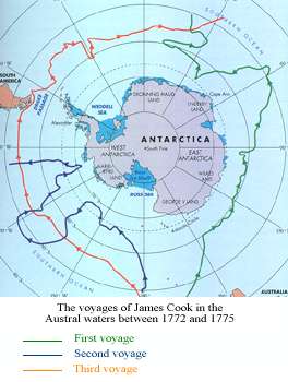
It is to James Cook that the decision finally to sail due South is attributed, thereby approaching the goal that had been coveted for so long. For three long years, between 1772 and 1775, he who was frequently described as the gentlest and most humane round-the-world sailor, was to criss-cross the South Seas, covering more than 10,000 nautical miles, aboard the colliers "Resolution" and "Adventure". For many months, while his sails and rigs were sporadically paralysed by snow and ice, he was to flirt with icebergs and hug the icy shores, forever searching, in the immensity of the ice floe, for a channel that would finally enable him to reach land and acquire new territorial possessions for his Kingdom. It was then that, for the first time in the world, the Antarctic Polar Circle was penetrated at latitude 66°33' South and longitude 106°54' West. He was also to be the first to describe the icy shores of the Antarctic Continent.
Cook's explorations were of capital importance for more than one reason. Firstly, they finally swept away the Antarctic myth, a land coveted by all and blessed, apparently, with an ideal climate… By following, as he did, the fringe of the ice floe right around the globe between latitudes 60° and 70°, Cook gave the world to understand that, if a continent were to exist beyond the latitudes of his explorations, it would have to be located near the pole, which was uninhabitable and lifeless; there was therefore virtually no point in taking a closer look at what was happening there. Unless… Secondly: in his logbook, Cook had noted the presence of immense seal colonies and numerous whales in those inhospitable waters. Although the Antarctic might no longer be titillating national envies, its waters could, on the other hand, be more than interesting. The information did not fail to impress certain merchants. The great commercial venture of the South Seas was about to take off…
Forty years after the death of James Cook, Russia in turn despatched its forces into the Great South. Under the command of the navigator Faddei Faddeievich Bellingshausen, two ships, Mirnyi and Vostok, managed on two occasions to venture beyond the 66th parallel and to penetrate the Antarctic Circle, despite the frequency and violence of the storms that were pushing them northwards. During the second expedition, in January 1820, they sailed along more than 600 kilometres of a frozen, snow-covered shoreline that they clearly could still not call "continental". But on the 28th of that month, when the expedition was sailing to the west of the Antarctic Peninsula, the look-out signalled the top of a mountain without snow at about 70 kilometres away from the ship: therefore there was well and truly land at that precise point on their course. Bellingshausen named the discovered coast Alexander I, in the belief that it was a question of at least a piece of shore of the famous Southern Continent. Alas, it was only an island, which since then has been called "Alexander". On their return from two year's of arduous expedition, the Russians greeted the explorers with almost universal indifference: in their view, Bellingshausen's discovery was not sufficiently spectacular…
Seal Wars and Brainwashing.
It was in the course of the 1820's that man was definitively to reach the Antarctic coasts. But for purposes of hunting rather than of exploring new lands. But, as at that time the seal wars were in full swing (between 1790 and 1800, South Georgia, the Cape Horn region and Chile had an annual combined production of more than 3 million seal skins) and the various shipowners urged their respective captains to keep their hunting grounds secret, one cannot attribute the first "Land Ahoy!" with any certainty to any one of them. One thing is certain: it was more considerations of trade and the profit motive that motivated those explorers to frequent those inhospitable latitudes and consequently to discover, one a piece of shore, one an island and one a sea or a chain of mountains. 
Two names are to be pinpointed for marking that period of the early 19th century: on the one hand, William Smith who, unable to round the Horn because of a storm, was forced to turn his vessel to the South and perceived, he too, land in the distance. Because he had not initially plumbed those waters, and had therefore been unable to interest the British authorities stationed on the Pacific coast of Chile, he returned to the area of his place of discovery, sailed along a string of islands, let out his fathoms and measured a depth of only 65 metres! On this occasion, without further doubt, the ocean had been conquered. He disembarked on a piece of land and planted the Union Jack on what he was to call the South Shetlands (an archipelago formed by a hundred or so islands with contours shredded by glacial erosion and covering an overall area of 1,300km²). On the other, Captain Edward Bransfield (a strait bears his name today) who, a few months later, was to set off with Smith on a third voyage and sail for many weeks in the waters of the archipelago in order to proceed with the necessary disembarkation to formalise his compatriot's discoveries.
As a result, the Antarctic Continent would no longer remain as mysterious as it had been in the past. Despite the fact that the discoverers were careful not to reveal the position of the game-laden waters that they had discovered, the voyages of Smith and Bransfield were to set off a veritable rush towards the gold that seal-and whale-hunting represented at that time. Now, the southern waters were no longer as terrifying as before: one could finally land on one of those numerous islands and set up a semblance of a base there, for as long as it took to unleash a small massacre. At that time, trading in sealskin was hugely profitable: during the summer of 1821, more than 50 ships of various nationalities were, in effect, criss-crossing the Antarctic waters.
The inevitable happened: it was to these vessels and their skippers that historians attribute the real discovery of the Antarctic Continent. Among them, the English navigator, John Davis, without doubt more adventurous and smarter than the others, fled the hoards of hunters and headed South. Anchoring in what is now Hughes Bay, he was certainly the first person distinctly to write that the great stretch of land that he could see from his ship and to which he was sending a longboat - not for the purpose of setting foot on land and claiming another discovery but in tireless pursuit of seal - must well and truly be part of the Southern Continent. Another, Nathaniel Palmer, captain of the Hero, a 45-ton sloop, was to claim, for his part, many years after returning from the Antarctic waters, that he was the first to have discovered the shores of the Antarctic Peninsula.
Take a quick look at the map of the Antarctic: it was the seas and islands to the Northwest of the peninsula, that, little by little, were in the process of being discovered. At the same time, an English mariner, James Weddell, the great eternal seal-hunter, also inscribed his name in the annals of the Antarctic; thanks to the particulary clement temperatures and conditions of the ice that he encountered during that month of February 1823, he managed, in effect, to conduct his vessels as far as latitude 74°15' - at least that is what he wrote in his logbook - or nearly 400km further south that the furthest point reached by Cook in 1774; he thus discovered the sea that bears his name today.
To be continued next page

The following sources have been used to write this chapter, and Chapter 3 "Dramas, Tragedies and Feats".
Antarctica, The Extraordinary History Of Man's Conquest Of The Frozen Continent, Reader's Digest Association Limited, Australia, 1985
The Explorations Of Antarctica, The Last Unspoilt Continent, G.E. Fogg & David Smith.
Fifteen Months In The Antarctic, Adrien De Gerlache.
Victory Over The Antarctic Night, Adrien De Gerlache.
The Odyssey Of The Endurance, The First Attempt To Cross The Antarctic, Sir Ernest Shackleton.
Explore Antarctica, Louise Crossley.
At The Heart Of The Antarctic, Towards The South Pole, 1908-1909, Sir Ernest Shackleton.
Explorers and Explorations, Raymond Cartier.
|