|
|
|
A Discovery waiting to be made (Page 2)
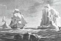
Even if it had been seen from a distance, the Antarctic Continent was not going to surrender so quickly. Certainly, since the explorations undertaken by the captains of the Enderby Brothers firm - a British seal-and whale-hunting company - and since the attempts of an officer of the French navy, Sébastien César Dumont d'Urville, finally to discover those famous Terrae Incognitae, it was known that a land well and truly existed to the South of New Zealand and beyond the Antarctic Polar Circle; it was also known that volcanic activity existed in that part of the world and that scurvy could decimate the bone and sinew of a crew in just a few days. But there was still no confirmation that the bits of mountains, the black rocks and the plots of land that the sailors and their lookouts could see all the time actually belonged to the so highly sought-after continent. On 21 January 1840, however, in the frenzy of what they took to be a tremendous success, Dumont d'Urville's men set foot on a tiny islet close to the Antarctic coast and planted the French flag on it. A few days later, Astrolabe and Zélée - the two units under the command of the French Navy - came across the brig Porpoise captained by the American, Charles Wilkes; Dumont d'Urville knew that the Americans also wanted to be the first to lay claim to the discovery of the Antarctic Continent. On the subject of that encounter in the southern waters, the archives are contradictory; some records assert that it was Dumont d'Urville who fled at the sight of the American vessel, whereas others claim, on the contrary, that it was the American who did not do honours to the French Captain. Be that as it may, no communication was exchanged between the two ships; this sign is a clear indication of the prevailing state of mind in which those voyages of exploration were unfolding in the middle of the 19th century. At the time, in effect, there was a genuine wind of madness blowing through the tales of the great explorers, each hoping of course to be able to lay claim to a part of the discovery of the great continent. So? Should the discovery of the continent be attributed to the Frenchman Dumont d'Urville or to the impressive fleet commanded by the American Charles Wilkes - in all, six ships with different missions? In his logbook, the latter made accurate drawings of the mountains that he had seen during his exploratory campaigns in the South Seas. "These are without the slightest doubt mountains that prove the existence and the position of the Antarctic Continent", he ceaselessly claimed to all who were demanding additional proof. The flames of the quarrels were so fanned by public opinion that the American Captain - accused of lying by his own officers - had to appear before a court martial: the few of his shipmates that remained loyal to him had to swear on their honour that that had well and truly seen the land that their "skipper" had proclaimed to be the Antarctic Continent.
With this voyage, a new era began, one that was to see scientific interest overtake economic or territorial preoccupations. The British Navy was, in effect, supported by a team of botanists, doctors and other naturalists who had a mission to found a research base in Tasmania and to get as close as they could to the magnetic South Pole. Having arrived in the area (on 16 August 1840), while he was supervising the prisoners who were in the process of building his conservatory, he had time to discover in the local press the accounts of the discoveries of his two predecessors, Wilkes and Dumont d'Urville. They too had been looking for the magnetic South Pole! However, Ross considered this area as his private preserve: irritated by what he had read, he even disdained from thanking Wilkes, who had however left him some valuable information about the route that he had to follow. And when, a few months later (November 1840), the expedition took to the sea again aboard his two ships, Erebus and Terror, its leader decided to exercise his right, which His Gracious Majesty's Government had accorded him, to choose for himself his course for approaching the Antarctic Continent: which is how Ross opted for a more easterly meridian, thereby following nobody's example. Even if his heading was more from the West, the London navigator did not escape the fate of those who had ventured on to that side of the continent: he effectively soon found himself confronted by an impassable ice floe that he decided to skirt to the West. But Ross, perhaps more than anyone else, was driven by the spirit of discovery; and perhaps, more than anybody else, by the desire to establish a new record latitude. Eighteen days after leaving Tasmania, Erebus and Terror picked their way South and became embroiled in a confusion of ice blocks, ice floes, icebergs, soft ice and shattered islets: in short, they forced their way through the ice floe and, two days later, still heading South, found themselves once again in open water. It was a historic moment: Ross had just discovered the Inland Sea to which his name is attached. Continuing his course, Ross planted the Union Jack on Possession Island, then on Franklin Island. But there were still surprises in store for the expedition: on 28 January, the crew perceived, just a few miles away from the ship, an active volcanic mountain which reached a height of more than 3,000 metres: Ross named it Mount Erebus. Pushing his exploration still further, Ross realised that he was confronted by a continuous line of ice that seemed to rise as they approached it. It was a veritable ice cliff higher than the rigging of his ship and completely flat at the top: the Captain christened this natural rampart Victoria Barrier. Later, this impassable obstacle was to become the famous Ross Barrier. After these important discoveries, the British mariner was to remain a further three long years in the Southern Hemisphere, wintering either in Tasmania or on the Falkland Islands. Aboard his two ships Erebus and Terror, he was to return twice to the Antarctic waters; the first time, to the place of his discoveries in an attempt to discover a break that would nevertheless enable his ships to advance through the wall of ice, and the other, into the Weddell Sea in a further attempt to break the southern latitude record. But Ross was unlucky; on each occasion the ice floe soared before his ships, thus definitively barring him from the passage to the continent.
Why was scientific research taking over? Because it was only natural, having criss-crossed the world's seas in search of new lands, for man to wonder what all those oceans contained in the way of wealth. And because Europeans wanted to establish regular contact with the people that had settled in the distant lands that they had colonised. At that time, the submarine telegraphic cable was the only tool capable of providing communication between two continents. It was thus in 1851 that the first physical France/England connection was laid; a few years later, a cable was to be deployed on the beach of the Skellig Islands (to the Southwest of Ireland) and unwound on the bed of the Atlantic to resurface, some 4,000km away, on a beach in New England. Before this period, there was certainly interest in the phenomenon of the ocean tides and salinity; but this time, the manufacturing and laying costs of such cables required a close study of the seabeds and waters before embarking upon such an adventure. It was in this context that oceanography developed. And this was even going as far, in the Seventies, as to explore the Antarctic seabeds. An initial expedition was therefore organised by the British Admiralty under the leadership of Sir Charles Wyville Thompson: the three-master Challenger (a former war corvette converted into an oceanographic ship) which left Portsmouth on 21 December 1872, was for four years to criss-cross the world's oceans, particularly the waters of the Southern Hemisphere. Equipped with scientific instruments of all kinds, the ship, which was the first steam/sail vessel to penetrate the Antarctic Polar Circle, covered more than 70,000 nautical miles across all the seas of the world; the dozens of researchers that were on board took soundings as frequently as they could, and collected samples, sediment and water, together with species of marine life.
|