See also our comparative map of the Arctic expeditions of spring 2002
 Saturday 4 May
It was on May 1 at 07.45 (local time) that the Eric Philips and Jon Muir duo successfully reached the Pole after a trek - often harassing - of 58 days (they started from a place about fifty kilometres away from Cape Arktichewski).
They are the first polar adventurers to get to the Pole this year. And the first Australians to pull off such a feat (unassisted to the North Pole).
Don't forget that they were unassisted in this trek. It was their first attempt on the North Pole.
Friday 12 April
Throughout last week, there was no news of the two Australians. All that was wrong was a fault with their Argos beacon. An Antonov located them and they are continuing their trek towards the North Pole. They are progressing quietly and are fighting fit. The latest message dating from 10 April gives their position as: 86°13' N / 86°38' E. They are 418 km from the Pole, and have covered 508 km so far.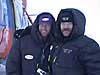
Their last press communiqué : F11 Apr 2002 - Fiona Brook
Eric Philips and Jon Muir are on their way to the North Pole on schedule despite the setbacks of being "lost" to the support team last week and out of phone contact for over ten days.
After not having any satellite communication with the trekkers for four days, Jon and Eric were located on April 3rd by a plane diverted from its normal course to check on them. As the plane flew over, the guys gave their thumbs up to show all was well. On April 4th the plane flew over again and was able to determine their position at 84 degrees 54 minutes North, 88 degrees 58 minutes East. It was confirmed that they were camped near a "polynia", an open lead of water much larger than usual that may have slowed them down for a while. Also, there is no truth to the story that the Ceropolex plane encountered any difficulties in this flight.
Remarkably, on April 8th the support team started to receive information from the Argos Beacon. The new coordinates were 84 degrees 51 minutes North 91 degrees 19 minutes East, a temperature range from -32.8C to -20.3, and the good news message of "Spirits high, confident."
It appears that all the overhead activity had made Eric and Jon think something was amiss. They must have looked over the Argos tracker and reseated the antenna, which had been damaged when Eric's fully loaded kayak fell off the truck on the way to the airport.
So the unstoppable pair continues on. Late April 10th the Argos information has changed to 86 degrees 13 minutes North, 86 degrees 38 minutes East and the message is "Good conditions, sledding" which means that they are making good time and covering distance on their skis.
The Globetag Icetrek has covered 508 km on their way to the Pole, with another 418 km to go. Jon and Eric aim to arrive at their destination in the first few days of May.
Brigitte Muir said, "It has been a huge relief to see the boys are moving well, and I am glad we sent in the Cerpolex plane to check on their condition and position. It probably made them aware that something was amiss. They must have had a close look at the Argos and realised that it needed a bit of TLC! Whatever they did to it, it worked! Argos is a reliable means of communication used by adventurers the world over. It is my belief that Jon and Eric can still make it to the North Pole unsupported, and I am sending them good vibes every day! Go boys go!!"
Susy Blair, Eric Philips wife added, "It has been a long week but I always felt that the problem was most likely to be damage to their equipment. In the first 16 days of the trip they came face to face with a polar bear, survived a dip in the Arctic Ocean and lost a ski, a skin and a binding. Despite all this they have managed to progress well so I have great confidence in their strength, determination and ability to improvise."
Wednesday 3 April
From their website :
Eric Philips and Jon Muir, the first Australians to trek to the North Pole unassisted, have been out of satellite contact for the past three days. At this time there is no cause for alarm. The ground support team in Australia has determined that the Argos Satellite Beacon that keeps track of Eric and Jon has failed.
The last position recorded by the satellite was 84 degrees North, 91 degrees East, at 11:18pm, 31 March. To this point they have travelled 351 kilometres in 27 days with 570 kilometres to go. The latest report indicates that the conditions are good and that the sledding has been swift, traveling up to 20 km a day. Because of this positive news the Globetag Icetrek support team recognize that it is unlikely any further action needs to be taken at this point.
An overflight of their route by Cerpolex Logistic team to the most recent recording location has been arranged with a French team that is located at an intermediate base not far from where the team started. This overflight will confirm their position and their situation. After the report from the overflight team has been received, any further decisions regarding re-supply will be made.
Jon Muir and Eric Philips are incredibly resourceful men who are very capable in any situation. They may not even be aware that the satellite beacon is not functioning and are going about the Icetrek as if nothing has happened.
Monday 1 April
A report on their site, for 22 March, tells of exactly the same incident that affected the two polar explorers in our Compaq Pole II expedition a few days ago. A fall into the water! Jon Muir sank into the icy water up to his chest when the ambient temperature was -28°C. He lost a ski in the adventure, and one of the fixings. Unlike Alain and Dixie, who were able to continue walking on the day of their fall, Jon and Eric had to pitch camp and devote the rest of the day to drying clothes.
Since that date, there has been no written communication on their site.
Nevertheless, their position is known for 31 March: 84° 863 N / 91° 218 E; they covered 354 km, at an average of 20.4 km per day. On 31 March, the Pole was still 570 km away. So making good progress. And, it would appear, better ice conditions than where the Belgians are walking.
Tuesday 19 March
The two Australians were dropped on 4 March at 80° 43' N / 96°50' E, or around fifty km from Cape Arktichevski; just like the Chinese and the other two Australians (Jarvis and Treseder) who are attempting the same feat along the same route at the same time.
The fact of being dropped 50 km from the usual starting point may seem an insignificant detail for the majority of people following the progress of the polar expeditions. But it isn't: because in this milieu of great adventurers, this type of detail can be important. At a time when we hear of one exploit after another, and there are many more of them, at a time when great adventures are no longer the preserve of professionals, every achievement is measured down to the last millimetre, put under the microscope, analysed and you might even say dissected. And this fact of having been dropped 50 km beyond Cape Arktishevski, for example, will certainly be taken into account by some people when it comes to comparing polar raids on this route. It has to be said that the world of great adventures is not always marked by total honesty; and that can be seen from the dropping beyond the open water. Because while the Philips-Muir site clearly shows that the men were dropped 50 km north, on the site of their compatriots, on the other hand, it is shown that the Jarvis-Treseder duo set off from Arktishevski.
After that digression, the conditions for progress are relatively good for Eric and Jon. The terrain is not too broken-up, the temperatures are cold but bearable, they have bears for company, and are in excellent physical shape - they are also old hands when it comes to polar adventures (see their site). On 19 March, they were at 83°32' N / 92°06'E; they had covered 208.4 km in 15 days (13.8 km per day) and were still 716.9 km from the pole.